|
The gateway that you will meet before coming into Lac Duong town.
Just go straight all the way and the road will lead you to the Lang Biang entrance. |
 |
This humble little shop has the best Bun Bo Hue soup that I've tasted in many years.
The beef and pork is kinda tough but the soup is heavenly. This young man said his mum
is from Hue and thus makes authentic Bun Bo Hue.
Address : 144, Lang Bian Street (less than 1km before the park on the right) |
 |
The single main street running through Lac Duong town.
You can see the Lang Biang entrance at the end of the street. |
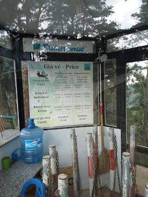
2. FEE OR FREE. It depends on what you want to do.
FEE: Locals pay the entrance fee of 30,000vnd (same for foreigners) to enter the park and take photos at the Lang Biang sign – not really worth it if you ask me. To make it worthwhile, you should take the jeep to the top to enjoy the view. Rental for a whole jeep is 360,000vnd for 6 pax (60,000vnd/pax). If you’re alone like me, you’ll need to wait for 5 others or pay the entire amount yourself. Just go to the payment counter and leave your name there (at least there’s a queue system here). You will be called when your turn is due. The 60k you pay is for the ride up and down – believe me, it is worth paying.
 |
| Entrance to Lang Biang Park |
 |
| A different angle |
 |
| Lang Biang Jeep - Rental is 360k/jeep for 6 pax or 60k/pax |
 |
| The jeeps will take the road in the background to go up to Radar Peak. |
 |
| 180 degree view |
 |
| Rest Area has cafetaria, toilets, shops |
FREE: If all you want to do is trek up and down, then there's no need to go through the official entrance and pay 30k. There is a track on the immediate right of the entrance that will take you all the way up to the viewing peak, via leg power. (See my photos) The lady at the ticketing counter told me it takes about 3 hours to trek up and of course coming down is much faster.
 |
If you're taking the jeep, you'll have to pay the park entrance fee of 30k
as well as the price for the jeep depending on how many there are in your group.
If you're just trekking, then take the very visible track on the right. |
 |
This is where you start your free walk. On the left is the official Rest Area of
Liang Biang Park. You can't go in to the park from this track.
You can buy your water from the shops just before this track. |
IMO: Unless you’re the trekking kind who love to stress out your leg muscles, my advice is to take the jeep up and trek down, especially if you're just a normal being like me. I took the jeep up (it's still 60k) and trekked down – a very lovely walk among the pine forest on a sunny day. If it’s rainy, that’ll be a different story totally. Needless to say, climbing up when the ground is wet will be all the harder. Main reason is because of the ground condition, which is already bald from the years of usage – that makes it worse and slippery both up and down. And you might not get to see any view if it’s cloudy or misty. I saw a few rather weary tourists walking up – I think they didn’t realize it’s a rather tiring climb uphill all the way for 2.5 to 3 hours – that’s why the jeep is good.
 |
| Ticketing Booth. That's the lady who said it takes about 3 hours to climb up. |
3. TREKKING UP AND DOWN
The directions are much clearer coming down than going up. There are about 7-8 blue GO UP-GO DOWN signs to guide you along the forest trail.
 |
| 7-8 such signs to guide you along the first part of the way (4.3km) |
 |
| This is the map found at the Lang Biang Rest Area. |
 |
| I added the details based on the map found at the Split Point to make it easier for hikers |
UP: Take the track on the immediate right of the official entrance. Going up is tricky as you need to know where to turn off to go up. (See photos below) First, you’ll come to a purple house a few hundred metres after the start.
 |
This is the view of the purple house when you're coming back.
On the way up, you'll see its back view. |
Next, you’ll see a green house on the right a little later. Right after this green house the track turns 90 degrees to the right. That’s where you go straight up instead of following the track. It’s uphill all the way in the pine forest until you hit the road (4.3km) later.
 |
This place is several hundred metres from the start point.
You can't miss it. |
 |
The first part of the forest trail is a series of gullies eroded by the rain. Don't worry too much.
Just walk on and the path goes through some coffee plantations.
Lovely views. |
 |
| 2 tourists coming down from the trail. |
 |
| The gullies that I was telling you about. Photo taken when I was going down. |
 |
| You'll pass some coffee plantations with lovely views on the way up. |
 |
This lone tree is another landmark. This photo was taken going down.
Going up, it will be on your right. Straight ahead will be the pine forest. |
From there, you’ll have to follow the road to Radar Peak as there’s no more forest tracks. From the start point below to this intersection, it's about 4.3km (please see map).
 |
The lovely pine forest after the lone tree.
You will walk through this all the way until you come up to the road. |
100m up and to your right is the split point – the jungle trail on the right leads to the real McCoy Lang Biang Peak (there’s a payment booth there; I think it’s a 20k ticket if it's manned); the left bitumen road goes to Radar Peak (2 km) – that’s where all the jeeps go to as the views are there.
DOWN : If you have taken the jeep up like me, then walk down along the road until you hit the split point to Mt Lang Biang peak. You can see a blue sign from here (100m down the road). That’s where you take the forest trail down. The rest of your walk is a piece of cake.
 |
This one and only sign will be staring at you on your way down - along the main road from Radar Peak.
It shows you where to branch off from the main road onto the forest trail. |
4. WHEN TO GO
It’s defintely not a good idea if it’s a rainy day. Better to go on a clear sunny day. I was there on 2 days. The first time in the afternoon about 2.30pm on a Wednesday. Unless you’re prepared to pay 360k for a solo jeep ride up, this is not a good time. Very few visitors, and even fewer wanting to go up via the jeep. I waited for a while before finally taking a walk by myself. The next morning, Thursday, I came about 7.30am. There were a lot more visitors at this time, and it wasn’t long before I was called to join one of the jeeps up.
 |
Jeep Booking Booth. You can leave your name with them if you're a group of less than 6.
Alternatively, you can book a whole jeep at 360k. |
5. THERE ARE 2 PEAKS!
RADAR PEAK - that’s the place where the jeeps take the tourists to. It’s a nice view there when the sky is clear. It’s touristy – what do you expect? There’s a café and restaurant where you can take your meals/drinks and some souvenir shops, pony rides etc. You are supposed to take the same jeep down (good value for your 60k) so remember to check with the driver how long you have at the place. I overheard it's about 30 minutes. I didn’t check as I intended to trek down.
 |
| Why it's called Radar Peak |
 |
This is where the jeeps will wait to bring tourists down.
Please remember you have to take the same jeep down - so check with the driver and don't get left behind. |
 |
| Cafetaria at Radar Peak |
 |
| You can take a pony ride |
 |
| Poor poor eagles!! |
 |
| My cafe sua da |
 |
| You can enjoy your cafe sua da and the view here |
 |
| Another way into the cafetaria |
 |
| Me at Radar Peak |
LANG BIANG PEAK – this is the true Lang Biang Peak. There’s a turn off (see the map) that you can’t miss at the split point. That’s for those who want to trek to the authentic Lang Biang Peak. I didn’t trek that way so I can’t say much about it.
6. POINTS TO NOTE
Take note that if you bike there, the bike park closes at 5pm. There’s a nice Rest Area after the entrance with lots of seating and the toilets are nice and clean. If you’re taking the bus, please remember to ask about the last bus. I saw 4 tourists walking in the rain after 5pm – I think they missed the last bus. They should have asked one of the locals to call a taxi for them. It’ll take ages for them to walk back to Dalat city. Wear proper trekking shoes if you’re trekking – saw a couple in sports shoes who told me they regretted not wearing trekking shoes. Bring an umbrella/rain coat if you’re in Dalat during the rainy season but it's best not to go during a rainy day, or even after some rain.
 |
| Poor horse painted to look like a zebra |
 |
| Birds of Lang Biang |
 |
| Green-backed Tit |
 |
| Black Bulbul |
 |
| Eurasian Jay |